
Vodič Apartman Paklenica
Razgledavanje
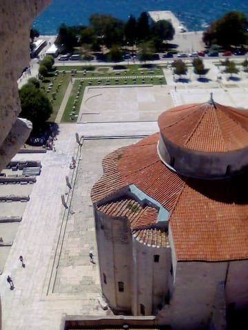
Nacionalni park Paklenica udaljen je 2 km od našeg objekta. Za ljubitelje šetnji svakako posjetiti.
Paklenica National Park is 2 km from our facility. A must visit for lovers of walks.
Planinarenje, auto safari. Obilazak moguć uz vodiča. Informacije potražiti u turističkom uredu u centru Starigrada.
Mountaineering, car safari. Tour possible with a guide. Find information at the tourist office in the center of Starigrad.
18 personas locales recomiendan
Tulove Grede
Planinarenje, auto safari. Obilazak moguć uz vodiča. Informacije potražiti u turističkom uredu u centru Starigrada.
Mountaineering, car safari. Tour possible with a guide. Find information at the tourist office in the center of Starigrad.
Odličan izbor za izlet u prirodu. Moguć je obilazak automobilom ili biciklom. U ponudi je i domaća kuhinja. Udaljenost 40km od našeg objekta.
An excellent choice for a trip to nature. It is possible to tour by car or bicycle. Local cuisine is also offered. Distance 40 km from our facility.
255 personas locales recomiendan
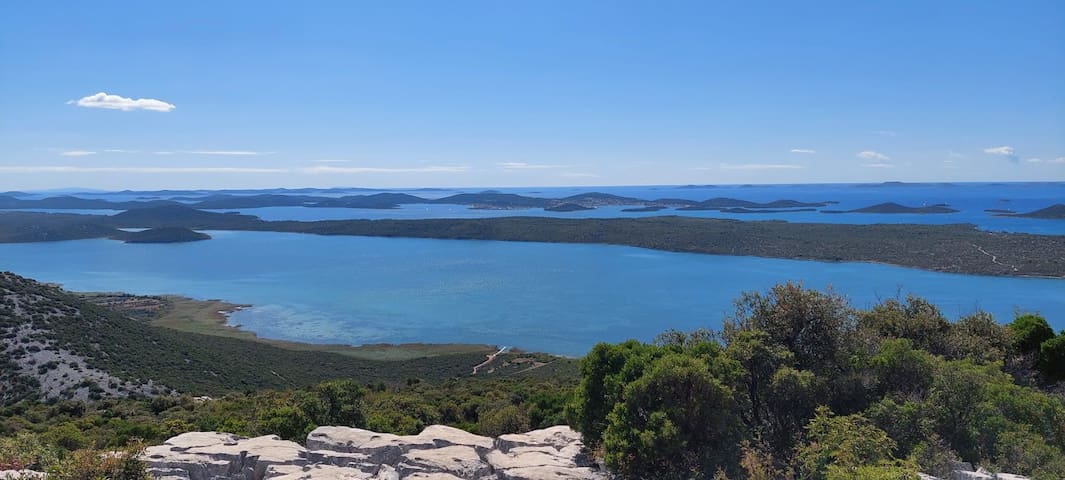
Lake Vrana
Odličan izbor za izlet u prirodu. Moguć je obilazak automobilom ili biciklom. U ponudi je i domaća kuhinja. Udaljenost 40km od našeg objekta.
An excellent choice for a trip to nature. It is possible to tour by car or bicycle. Local cuisine is also offered. Distance 40 km from our facility.
Predivno mjesto na rijeci Zrmanja. Udaljeno 50 km od našeg objekta.
A wonderful place on the river Zrmanja. 50 km from our facility.
12 personas locales recomiendan
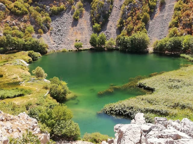
Kudin most na Krupi
Predivno mjesto na rijeci Zrmanja. Udaljeno 50 km od našeg objekta.
A wonderful place on the river Zrmanja. 50 km from our facility.
Pješčana plaža i plitka uvala u kojoj ćete hodati daleko po pijesku. Udaljena 20km od našeg objekta.
A sandy beach and a shallow bay where you will walk far on the sand. 20 km from our facility.
Crkva Sveti Duh, Posedarje
Pješčana plaža i plitka uvala u kojoj ćete hodati daleko po pijesku. Udaljena 20km od našeg objekta.
A sandy beach and a shallow bay where you will walk far on the sand. 20 km from our facility.
Zavratnica je zaštićeni krajolik i predstavlja jednu od najljepših uvala na Hrvatskom Jadranu. Od 1981. godine pripada Parku prirode Velebit Udaljenost od našeg objekta 45km.
Zavratnica is a protected landscape and represents one of the most beautiful bays on the Croatian Adriatic. It belongs to the Velebit Nature Park since 1981. The distance from our facility is 45 km.
105 personas locales recomiendan
Zavratnica
Zavratnica je zaštićeni krajolik i predstavlja jednu od najljepših uvala na Hrvatskom Jadranu. Od 1981. godine pripada Parku prirode Velebit Udaljenost od našeg objekta 45km.
Zavratnica is a protected landscape and represents one of the most beautiful bays on the Croatian Adriatic. It belongs to the Velebit Nature Park since 1981. The distance from our facility is 45 km.
Zavratnica privlači i ronioce, koji dolaze ploviti oko olupine koja „spava“ na oko 800 metara od plaže, na nekoliko metara dubine. Kad je vidljivost dobra, a more kristalno čisto, potopljeni ratni brod iz Drugog svjetskog rata može se vidjeti s kopna.
Zavratnica also attracts divers, who come to sail around the wreck that is "sleeping" about 800 meters from the beach, at a depth of several meters. When visibility is good and the sea is crystal clear, a sunken World War II warship can be seen from land.
19 personas locales recomiendan
Uvala Zavratnica
Zavratnica privlači i ronioce, koji dolaze ploviti oko olupine koja „spava“ na oko 800 metara od plaže, na nekoliko metara dubine. Kad je vidljivost dobra, a more kristalno čisto, potopljeni ratni brod iz Drugog svjetskog rata može se vidjeti s kopna.
Zavratnica also attracts divers, who come to sail around the wreck that is "sleeping" about 800 meters from the beach, at a depth of several meters. When visibility is good and the sea is crystal clear, a sunken World War II warship can be seen from land.
Križni put u Posedarju, najmasivniji i po svom materijalu najteži u svijetu. Započinje na 80 metara nadmorske visine, a završava vidikovcem na 200 m nadmorske visine, gdje se pod plavetnilom neba prostire pogled na Novigradsko more i planinski lanac Velebita. Križni put se sastoji od 14 postaja, kamenih gromada na kojima su isklesani biblijski motivi križnoga puta, te Isusova grobnica i Uskrsnuće. Svaka bijela kamena postaja Križnog puta dugog 2,5 kilometara, visoka je 2,5 metra, a teška između pet i deset tona. Voditelj cijelog projekta je amaterski kipar i umjetnik Vinko Kajmak, koji je i pokretač tog iznimnog duhovno-umjetničkog djela i međunarodnog projekta. Udaljenost od našeg objekta iznosi 20km. Nalazi se u mjestu Posedarje.
Way of the Cross in Posedarje, the most massive and, in terms of its material, the most difficult in the world. It starts at 80 meters above sea level and ends with a viewpoint at 200 meters above sea level, where under the blue sky there is a view of the Novigrad Sea and the Velebit mountain range. The Way of the Cross consists of 14 stations, boulders on which biblical motifs of the Way of the Cross are carved, and Jesus' tomb and Resurrection. Each white stone Station of the Cross is 2.5 kilometers long, 2.5 meters high, and weighs between five and ten tons. The leader of the entire project is the amateur sculptor and artist Vinko Kajmak, who is also the initiator of this exceptional spiritual-artistic work and international project. The distance from our facility is 20 km. It is located in Posedarje.
Way of the Cross
Križni put u Posedarju, najmasivniji i po svom materijalu najteži u svijetu. Započinje na 80 metara nadmorske visine, a završava vidikovcem na 200 m nadmorske visine, gdje se pod plavetnilom neba prostire pogled na Novigradsko more i planinski lanac Velebita. Križni put se sastoji od 14 postaja, kamenih gromada na kojima su isklesani biblijski motivi križnoga puta, te Isusova grobnica i Uskrsnuće. Svaka bijela kamena postaja Križnog puta dugog 2,5 kilometara, visoka je 2,5 metra, a teška između pet i deset tona. Voditelj cijelog projekta je amaterski kipar i umjetnik Vinko Kajmak, koji je i pokretač tog iznimnog duhovno-umjetničkog djela i međunarodnog projekta. Udaljenost od našeg objekta iznosi 20km. Nalazi se u mjestu Posedarje.
Way of the Cross in Posedarje, the most massive and, in terms of its material, the most difficult in the world. It starts at 80 meters above sea level and ends with a viewpoint at 200 meters above sea level, where under the blue sky there is a view of the Novigrad Sea and the Velebit mountain range. The Way of the Cross consists of 14 stations, boulders on which biblical motifs of the Way of the Cross are carved, and Jesus' tomb and Resurrection. Each white stone Station of the Cross is 2.5 kilometers long, 2.5 meters high, and weighs between five and ten tons. The leader of the entire project is the amateur sculptor and artist Vinko Kajmak, who is also the initiator of this exceptional spiritual-artistic work and international project. The distance from our facility is 20 km. It is located in Posedarje.
Nacionalni park Plitvička jezera osobita je geološka i hidrogeološka krška pojava. Kompleks Plitvičkih jezera proglašen je nacionalnim parkom 8. travnja 1949. godine. To je najveći, najstariji i najposjećeniji hrvatski nacionalni park. Udaljen je cca.100km od Starigrada.
Plitvice Lakes National Park is a special geological and hydrogeological karst phenomenon. The Plitvice Lakes complex was declared a national park on April 8, 1949. It is the largest, oldest and most visited Croatian national park. It is about 100 km from Starigrad.
1554 personas locales recomiendan
Plitvice Lakes National Park
Nacionalni park Plitvička jezera osobita je geološka i hidrogeološka krška pojava. Kompleks Plitvičkih jezera proglašen je nacionalnim parkom 8. travnja 1949. godine. To je najveći, najstariji i najposjećeniji hrvatski nacionalni park. Udaljen je cca.100km od Starigrada.
Plitvice Lakes National Park is a special geological and hydrogeological karst phenomenon. The Plitvice Lakes complex was declared a national park on April 8, 1949. It is the largest, oldest and most visited Croatian national park. It is about 100 km from Starigrad.
Gradske četvrti
Starigrad Paklenica, Plaža Jaz
Beach Jaz in Starigrad. The beach consists of various facilities for children and adults
22 personas locales recomiendan
Starigrad
Starigrad Paklenica, Plaža Jaz
Beach Jaz in Starigrad. The beach consists of various facilities for children and adults
cave Manita peć, Starigrad Paklenica
Information about visiting cave can be found at entrance of National Park Paklenica
Manita peć
Paklenička ulicacave Manita peć, Starigrad Paklenica
Information about visiting cave can be found at entrance of National Park Paklenica
Pozdrav Suncu, djelo nagrađivanog zadarskog arhitekta Nikole Bašića, nalazi se na zapadnom djelu dijelu rive uz Morske Orgulje.Pozdrav Suncu sastoji se od tri stotine višeslojnih staklenih ploča postavljenih u razini rive, u obliku kruga promjera 22 metra. Ova jedinstvena urbana instalacija danju upija sunčevu svjetlost , a zalaskom Sunca uključuju se rasvjetni elementi ugrađeni u krug, te proizvode iznimno dojmljivu svjetlosnu igru.Ova atrakcija nalazi se u gradu Zadar, 45 km udaljenosti od Starigrada.
Salutation to the Sun, the work of award-winning Zadar architect Nikola Bašić, is located on the western part of the waterfront next to the Sea Organ.
Salutation to the Sun consists of three hundred multi-layered glass panels placed at the level of the waterfront, in the form of a circle with a diameter of 22 meters. This unique urban installation absorbs sunlight during the day, and when the sun sets, the lighting elements built into the circle turn on, producing an extremely impressive play of light. This attraction is located in the city of Zadar, 45 km from Starigrad.
456 personas locales recomiendan
The Greeting to the Sun
Istarska obalaPozdrav Suncu, djelo nagrađivanog zadarskog arhitekta Nikole Bašića, nalazi se na zapadnom djelu dijelu rive uz Morske Orgulje.Pozdrav Suncu sastoji se od tri stotine višeslojnih staklenih ploča postavljenih u razini rive, u obliku kruga promjera 22 metra. Ova jedinstvena urbana instalacija danju upija sunčevu svjetlost , a zalaskom Sunca uključuju se rasvjetni elementi ugrađeni u krug, te proizvode iznimno dojmljivu svjetlosnu igru.Ova atrakcija nalazi se u gradu Zadar, 45 km udaljenosti od Starigrada.
Salutation to the Sun, the work of award-winning Zadar architect Nikola Bašić, is located on the western part of the waterfront next to the Sea Organ.
Salutation to the Sun consists of three hundred multi-layered glass panels placed at the level of the waterfront, in the form of a circle with a diameter of 22 meters. This unique urban installation absorbs sunlight during the day, and when the sun sets, the lighting elements built into the circle turn on, producing an extremely impressive play of light. This attraction is located in the city of Zadar, 45 km from Starigrad.
Gastronomska scena
lokalna hrana, uvijek svježa ponuda
Local fresh food, good seafood and fish offer. Location; Maslenica
19 personas locales recomiendan

Restoran - Bistro Biser
44 Ul. Gojka Šuškalokalna hrana, uvijek svježa ponuda
Local fresh food, good seafood and fish offer. Location; Maslenica
Maškovića han Vrana
Old historical Han at place Vrana. Worth seeing.
Mali restorančić u starem zaseoku Marasovići u Starigrad Paklenici, udaljen svega 10 minuta hoda od našeg objekta. Restoran se nalazi u staroj restauriranoj kamenoj kući na samom ulazu u Nacionali park Paklenica.
A small restaurant in the old hamlet of Marasovići in Starigrad Paklenica, only a 10-minute walk from our facility. The restaurant is located in an old restored stone house at the entrance to the Paklenica National Park.
7 personas locales recomiendan
Taverna Konoba marasovici
49 Stari gradMali restorančić u starem zaseoku Marasovići u Starigrad Paklenici, udaljen svega 10 minuta hoda od našeg objekta. Restoran se nalazi u staroj restauriranoj kamenoj kući na samom ulazu u Nacionali park Paklenica.
A small restaurant in the old hamlet of Marasovići in Starigrad Paklenica, only a 10-minute walk from our facility. The restaurant is located in an old restored stone house at the entrance to the Paklenica National Park.
Kupanje, plaža, povijesni lokalitet
Lijepa šljunčana plaža za kupanje. Nice pebbled beach in Starigrad.
10 personas locales recomiendan
beach Večka Kula
Lijepa šljunčana plaža za kupanje. Nice pebbled beach in Starigrad.
Plaža
Plaža s hladom
U kampu Nacionanog parka nalazi se šljunčana plaža sa hladom. Plaža je udaljena 5 minuta hoda od naše kuće.
In the camp of the National Park there is a pebble beach with shade. The beach is a 5-minute walk from our house.
camp “Nacionalni park”
14a Ul. dr. Franje TuđmanaU kampu Nacionanog parka nalazi se šljunčana plaža sa hladom. Plaža je udaljena 5 minuta hoda od naše kuće.
In the camp of the National Park there is a pebble beach with shade. The beach is a 5-minute walk from our house.
Adventure
Muzej iluzija
2 Poljana Zemaljskog odboramuzej se nalazi u Zadru, 45 km od Starigrada
Fun Park Biograd
9 X.JankolovačkiKultura i povijest
Stari grad, povijesne znamenitosti, galerije, muzeji, izložbe, arhitektura, zabava, gastronomija, noćni život
776 personas locales recomiendan
Zadar
Stari grad, povijesne znamenitosti, galerije, muzeji, izložbe, arhitektura, zabava, gastronomija, noćni život
Povijesna znamenitost. Izgradnja Mašković Hana započela je 1644.godine po naređenju i sredstvima Jusufa Maškovića, porijeklom iz Vrane, visokog dostojanstvenika na sultanovom dvoru i vrhovnog admirala turske flote.U izgradnju su uložena značajna novčana sredstva, te je na njemu radilo čak 500 radnika dnevno.
Historical landmark. The construction of Mašković Han began in 1644 by the order and funds of Jusuf Mašković, a native of Vrana, a high dignitary at the Sultan's court and supreme admiral of the Turkish fleet. Considerable financial resources were invested in the construction, and as many as 500 workers worked on it daily.
50 personas locales recomiendan
Maškovića han Vrana
Povijesna znamenitost. Izgradnja Mašković Hana započela je 1644.godine po naređenju i sredstvima Jusufa Maškovića, porijeklom iz Vrane, visokog dostojanstvenika na sultanovom dvoru i vrhovnog admirala turske flote.U izgradnju su uložena značajna novčana sredstva, te je na njemu radilo čak 500 radnika dnevno.
Historical landmark. The construction of Mašković Han began in 1644 by the order and funds of Jusuf Mašković, a native of Vrana, a high dignitary at the Sultan's court and supreme admiral of the Turkish fleet. Considerable financial resources were invested in the construction, and as many as 500 workers worked on it daily.
Nin
Novigrad je slikovit gradić i luka u dubokoj uvali na južnoj obali Novigradskog mora. Novigradska luka sa svojim poput fjorda uvučenim kanalom svojevrsni je prirodni fenomen. Na sjevernoj obali kanala ispod tvrđave Fortice tijekom stoljeća nastala je povijesna jezgra naselja Novigrad.
Novigrad is a picturesque town and port in a deep bay on the southern coast of the Novigrad Sea. The port of Novigrad with its fjord-like canal is a kind of natural phenomenon. Over the centuries, the historical core of the Novigrad settlement was created on the northern bank of the canal below the Fortice fortress.
Kula Buta
Novigrad je slikovit gradić i luka u dubokoj uvali na južnoj obali Novigradskog mora. Novigradska luka sa svojim poput fjorda uvučenim kanalom svojevrsni je prirodni fenomen. Na sjevernoj obali kanala ispod tvrđave Fortice tijekom stoljeća nastala je povijesna jezgra naselja Novigrad.
Novigrad is a picturesque town and port in a deep bay on the southern coast of the Novigrad Sea. The port of Novigrad with its fjord-like canal is a kind of natural phenomenon. Over the centuries, the historical core of the Novigrad settlement was created on the northern bank of the canal below the Fortice fortress.
U malom pitoresknom gradiću Novigrad nalazi se Interpretacijski centar mora sa zanimljivostima iz pomorstva i ribarstva. Udaljen 25 km od našeg objekta,
In the small, picturesque town of Novigrad, there is a Sea Interpretation Center with interesting maritime and fishing topics. 25 km from our facility
Novigradsko more, 23243, Croacia
U malom pitoresknom gradiću Novigrad nalazi se Interpretacijski centar mora sa zanimljivostima iz pomorstva i ribarstva. Udaljen 25 km od našeg objekta,
In the small, picturesque town of Novigrad, there is a Sea Interpretation Center with interesting maritime and fishing topics. 25 km from our facility
Srednjovjekovna crkva smještena uz samu Jadransku magistralu između Starigrada i Selina. Oko crkve nalazi se groblje u koje se ukapalo od sredine 13.stoljeća. Sačuvani su upečatljivi nadgrobni spomenici u obliku masivnih kamenih ploča mjestimično ukrašenih jednostavnim, plitkim reljefnim prikazima, koji potiču iz 14-16.stoljeća. Crkva je izgrađena u predromaničkom starohrvatskom stilu, vjerojatno na prijelazu iz IX u X stoljeće.
Medieval church located along the Adriatic highway between Starigrad and Selin. Around the church there is a cemetery that has been used since the middle of the 13th century. Striking tombstones in the form of massive stone slabs, decorated in places with simple, shallow reliefs, originating from the 14th-16th centuries, have been preserved. The church was built in the pre-Romanesque Old Croatian style, probably at the turn of the 9th to the 10th century.
Sveti Petar
105 Ul. dr. Franje TuđmanaSrednjovjekovna crkva smještena uz samu Jadransku magistralu između Starigrada i Selina. Oko crkve nalazi se groblje u koje se ukapalo od sredine 13.stoljeća. Sačuvani su upečatljivi nadgrobni spomenici u obliku masivnih kamenih ploča mjestimično ukrašenih jednostavnim, plitkim reljefnim prikazima, koji potiču iz 14-16.stoljeća. Crkva je izgrađena u predromaničkom starohrvatskom stilu, vjerojatno na prijelazu iz IX u X stoljeće.
Medieval church located along the Adriatic highway between Starigrad and Selin. Around the church there is a cemetery that has been used since the middle of the 13th century. Striking tombstones in the form of massive stone slabs, decorated in places with simple, shallow reliefs, originating from the 14th-16th centuries, have been preserved. The church was built in the pre-Romanesque Old Croatian style, probably at the turn of the 9th to the 10th century.
The road from the center of Starigrad leads through the Brđani settlement (A. Stepinca street) and on to Uzpochivala to Opuvani Doc between the heads of Mali and Veliki Vitrenik.Mirila, stone monuments to the departed, can be found along the mountain paths, passes, elevations and clearings of Mt. Velebit. Mirila date from the times of the Velebit hamlets (17th–20th centuries), that mainly survived from animal husbandry.
They preserve the memories of persons who died on the mountain slopes and had to be carried to the village church and then to the cemetery where they were buried. On such arduous journeys, it was only permitted to stop, rest and place the deceased on the ground in one place - the place where the deceased would greet the sun for the last time.
Mirila Opuvani dolac
The road from the center of Starigrad leads through the Brđani settlement (A. Stepinca street) and on to Uzpochivala to Opuvani Doc between the heads of Mali and Veliki Vitrenik.Mirila, stone monuments to the departed, can be found along the mountain paths, passes, elevations and clearings of Mt. Velebit. Mirila date from the times of the Velebit hamlets (17th–20th centuries), that mainly survived from animal husbandry.
They preserve the memories of persons who died on the mountain slopes and had to be carried to the village church and then to the cemetery where they were buried. On such arduous journeys, it was only permitted to stop, rest and place the deceased on the ground in one place - the place where the deceased would greet the sun for the last time.