
Trigrad's Guidebook
Sightseeing
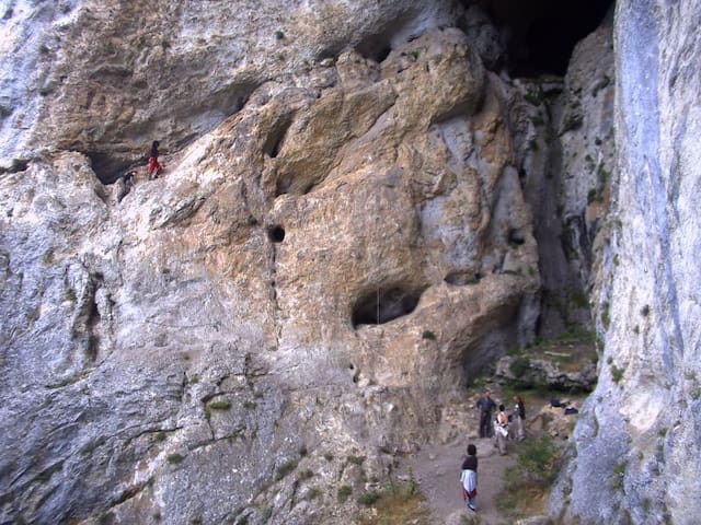
The cave is located 1.5 km north of the village of Trigrad in the Trigrad Gorge in the Rhodopes.
The Devil's Throat is an abyssal cave, which was formed as a result of the collapse of the earth's layers. Its main part is occupied by a large hall, which houses the highest underground waterfall on the Balkan Peninsula.
In Bulgaria we enjoy 33 of the 35 species of bats found in Europe. All of them are strictly protected by the Law on Biological Diversity throughout the country.
The devil's throat gives shelter to 4 species of bats that inhabit the cave during the different seasons. Through observations and catches with nets, the following have been established.
The Devil's Throat gives rise to various legends from the time of the Thracians. One of them says that it was here that Orpheus descended into the underworld of Hades to save his beloved Eurydice.
10 personas locales recomiendan
Devil's Throat Cave
The cave is located 1.5 km north of the village of Trigrad in the Trigrad Gorge in the Rhodopes.
The Devil's Throat is an abyssal cave, which was formed as a result of the collapse of the earth's layers. Its main part is occupied by a large hall, which houses the highest underground waterfall on the Balkan Peninsula.
In Bulgaria we enjoy 33 of the 35 species of bats found in Europe. All of them are strictly protected by the Law on Biological Diversity throughout the country.
The devil's throat gives shelter to 4 species of bats that inhabit the cave during the different seasons. Through observations and catches with nets, the following have been established.
The Devil's Throat gives rise to various legends from the time of the Thracians. One of them says that it was here that Orpheus descended into the underworld of Hades to save his beloved Eurydice.
Jagodina Cave is 10 km long and is located on three floors, of which only the third (lowest) is refined and electrified. A 1100-meter trail has been built for tourists. The entrance and exit to this floor are artificially dug tunnels with lengths of 150 and 80 m, respectively. The total displacement of the cave is 36 m.
The natural entrance of the cave leads to its first floor, where an ancient dwelling was discovered, inhabited around the 4th millennium BC. The finds say that it was home to skilled potters. The clay was extracted from the inside of the cave and from the bed of the Buynovska river. The dishes were baked in clay ovens. Residents have been forced to leave their homes after a landslide caused by an earthquake.
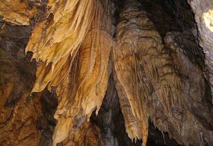
The cave is unique with its countless stalactites, stalagmites, stalactites, "curtains", "leopard skins" (differently colored rock layers), cave pearls. It has a constant temperature of 6 ° C and a humidity of 92%.
12 personas locales recomiendan
Yagodinska Cave
Jagodina Cave is 10 km long and is located on three floors, of which only the third (lowest) is refined and electrified. A 1100-meter trail has been built for tourists. The entrance and exit to this floor are artificially dug tunnels with lengths of 150 and 80 m, respectively. The total displacement of the cave is 36 m.
The natural entrance of the cave leads to its first floor, where an ancient dwelling was discovered, inhabited around the 4th millennium BC. The finds say that it was home to skilled potters. The clay was extracted from the inside of the cave and from the bed of the Buynovska river. The dishes were baked in clay ovens. Residents have been forced to leave their homes after a landslide caused by an earthquake.
The cave is unique with its countless stalactites, stalagmites, stalactites, "curtains", "leopard skins" (differently colored rock layers), cave pearls. It has a constant temperature of 6 ° C and a humidity of 92%.
The Haramiyska Cave is located opposite the Devil's Throat Cave in the protected area of the Trigrad Gorge, 1 km from the village of Trigrad and 26 km from the town of Devin.
The cave is composed of 2 caves connected by a 43-meter abyss. The total length of the cave is 510 meters, the slope is 45 degrees, the place has high humidity and in places with ice.
The cave, which is not electrified, is entered only with a guide and special equipment. Information about the order of entering the cave can be obtained from the box office or the guide of the Devil's Throat cave. Pre-registration is desirable. Places in the entry group are limited. The meeting place is in the morning up until 10 o'clock in the parking lot in front of the Devil's Throat.
The entrance to the Haramiyska Cave can be reached after a 20-meter vertical climb with the help of a guide and alpine equipment. You go down to the big hall inside after a 43-meter descent with a rope. Inside the cave are found archaeological finds from the Chalcolithic and Bronze Ages - tools, weaving tools and ceramics. At the entrance, visitors can see a decorative composition depicting primitive people.
The entrance fee is 40BGN.
Haramiiska Cave
The Haramiyska Cave is located opposite the Devil's Throat Cave in the protected area of the Trigrad Gorge, 1 km from the village of Trigrad and 26 km from the town of Devin.
The cave is composed of 2 caves connected by a 43-meter abyss. The total length of the cave is 510 meters, the slope is 45 degrees, the place has high humidity and in places with ice.
The cave, which is not electrified, is entered only with a guide and special equipment. Information about the order of entering the cave can be obtained from the box office or the guide of the Devil's Throat cave. Pre-registration is desirable. Places in the entry group are limited. The meeting place is in the morning up until 10 o'clock in the parking lot in front of the Devil's Throat.
The entrance to the Haramiyska Cave can be reached after a 20-meter vertical climb with the help of a guide and alpine equipment. You go down to the big hall inside after a 43-meter descent with a rope. Inside the cave are found archaeological finds from the Chalcolithic and Bronze Ages - tools, weaving tools and ceramics. At the entrance, visitors can see a decorative composition depicting primitive people.
The entrance fee is 40BGN.
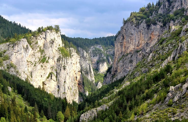
The Trigrad Gorge is a canyon of vertical marble rocks in the Rhodope Mountains. The gorge encloses the course of the Trigrad River, which plunges into the Devil's Throat Cave and 530 metres (1,740 ft) further emerges as a large karst spring. It later flows into the River Buynovska.
The gorge's west wall reaches 300 metres (980 ft) in height, while the east one extends up to 300–350 metres (980–1,150 ft). Initially, the two walls are about 300 m apart, but the gorge narrows to about 100 metres (330 ft) in the northern section. The gorge is 1.2 kilometres (0.75 mi) from the village of Trigrad at 1,450 metres (4,760 ft) above sea level and has a total length of 7 kilometres (4.3 mi), of which the gorge proper comprises 2–3 kilometres (1.2–1.9 mi).
Trigrad Gorge
The Trigrad Gorge is a canyon of vertical marble rocks in the Rhodope Mountains. The gorge encloses the course of the Trigrad River, which plunges into the Devil's Throat Cave and 530 metres (1,740 ft) further emerges as a large karst spring. It later flows into the River Buynovska.
The gorge's west wall reaches 300 metres (980 ft) in height, while the east one extends up to 300–350 metres (980–1,150 ft). Initially, the two walls are about 300 m apart, but the gorge narrows to about 100 metres (330 ft) in the northern section. The gorge is 1.2 kilometres (0.75 mi) from the village of Trigrad at 1,450 metres (4,760 ft) above sea level and has a total length of 7 kilometres (4.3 mi), of which the gorge proper comprises 2–3 kilometres (1.2–1.9 mi).
The Rhodope peak “Snezhanka” raised 1,926 meters in height. The resort of Pamporovo is situated at the foot of the peak. The larger part of the ski tracks of the resort starts namely from the peak, as their altitude varies between 1,926 and 1,400 meters.
A television tower rises on the Snezhanka peak, where a wonderful view opens to the entire surrounding area. Tourists can reach the Snezhanka peak by the ski lift “Studenets 2” in Pamporovo.
The beautiful nature in the region attracts tourists all year long. During the winter the Pamporovo resort offers very good conditions for winter sports – skiing, snowboarding, entertainment with snow mobiles, winter fishing, etc. During the summer the Rhodope mountain is suitable for hiking crossings, mountain biking, sport fishing, herb picking, and tourists can stay in any of the hospitable villages in the region or in the resort of Pamporovo. The towns of Chepelare and Smolyan are situated nearby.
Връх Снежанка - 1925,8 м
The Rhodope peak “Snezhanka” raised 1,926 meters in height. The resort of Pamporovo is situated at the foot of the peak. The larger part of the ski tracks of the resort starts namely from the peak, as their altitude varies between 1,926 and 1,400 meters.
A television tower rises on the Snezhanka peak, where a wonderful view opens to the entire surrounding area. Tourists can reach the Snezhanka peak by the ski lift “Studenets 2” in Pamporovo.
The beautiful nature in the region attracts tourists all year long. During the winter the Pamporovo resort offers very good conditions for winter sports – skiing, snowboarding, entertainment with snow mobiles, winter fishing, etc. During the summer the Rhodope mountain is suitable for hiking crossings, mountain biking, sport fishing, herb picking, and tourists can stay in any of the hospitable villages in the region or in the resort of Pamporovo. The towns of Chepelare and Smolyan are situated nearby.
The Chairski Lakes are a group of nine glacial lakes in the Rodopi mountain, south-western Bulgaria. They are located in a large cirque called Chaira in the valley of the river Sandanska Bistritsa. They are situated between the peaks Mozgovishki and Prevalski Chukar at an altitude between 1,400 and 1,500 m. Their total area is around 92 decares which is with 30 decares less than the largest lake in Ririn, the Popovo Lake. Their total volume is 160,000 m³ which is eight time less than the Popovo lake.
Chairski Lakes
The Chairski Lakes are a group of nine glacial lakes in the Rodopi mountain, south-western Bulgaria. They are located in a large cirque called Chaira in the valley of the river Sandanska Bistritsa. They are situated between the peaks Mozgovishki and Prevalski Chukar at an altitude between 1,400 and 1,500 m. Their total area is around 92 decares which is with 30 decares less than the largest lake in Ririn, the Popovo Lake. Their total volume is 160,000 m³ which is eight time less than the Popovo lake.
Orlovo Oko (Eagle's Eye) is a sightseeing platform built at 1563 m above the sea level, next to the St Ilia peak in the Rhodope mountains and close to the village of Yagodina and the famous Yagodinska cave. This is a steel construction that raises 670 m above the picturesque Buynovsko gorge with its winding river and a road that runs along it. It can be reached on foot, by jeeps or by mountain bikes, the trail begins at the exit of the village of Yagodina in the direction of Trigrad and then follows the mountain ridge.The magnificent sightseeing spot reveals stunning views of the gorge and the nearby villages, as well as the Bulgarian and Greek mountains and peaks in the distance. You may be lucky to spot a golden eagle or wild goats who are among the most attractive inhabitants of this part of the Rhodope.
7 personas locales recomiendan
Eagle's Eye
Orlovo Oko (Eagle's Eye) is a sightseeing platform built at 1563 m above the sea level, next to the St Ilia peak in the Rhodope mountains and close to the village of Yagodina and the famous Yagodinska cave. This is a steel construction that raises 670 m above the picturesque Buynovsko gorge with its winding river and a road that runs along it. It can be reached on foot, by jeeps or by mountain bikes, the trail begins at the exit of the village of Yagodina in the direction of Trigrad and then follows the mountain ridge.The magnificent sightseeing spot reveals stunning views of the gorge and the nearby villages, as well as the Bulgarian and Greek mountains and peaks in the distance. You may be lucky to spot a golden eagle or wild goats who are among the most attractive inhabitants of this part of the Rhodope.
From Valchi Kamak there is a magnificent view of the "tail" of the Trigrad gorge, which begins 1.5 km north of the village of Trigrad and continues north to the village of Govren for about 7 km along the river Trigradska. Around the village of Govren the gorge is already much wider, the marble slopes are dotted with various karst forms, and in places are covered with spruce and fir forests. Valchi Kamak can be reached by off-road vehicle on black cart roads, through beautiful forests and meadows.
The fee for the jeep trip is BGN 10 per person, the starting point is from the junction for the village of Govren on the road between the town of Devin and the village of Trigrad. In clear weather from the unique tower, built by the local tourist association, there is a magnificent view of the neighboring villages and mountain peaks. You can even see Pirin Mountain.
Valchi kamak (Wolf Rock)
From Valchi Kamak there is a magnificent view of the "tail" of the Trigrad gorge, which begins 1.5 km north of the village of Trigrad and continues north to the village of Govren for about 7 km along the river Trigradska. Around the village of Govren the gorge is already much wider, the marble slopes are dotted with various karst forms, and in places are covered with spruce and fir forests. Valchi Kamak can be reached by off-road vehicle on black cart roads, through beautiful forests and meadows.
The fee for the jeep trip is BGN 10 per person, the starting point is from the junction for the village of Govren on the road between the town of Devin and the village of Trigrad. In clear weather from the unique tower, built by the local tourist association, there is a magnificent view of the neighboring villages and mountain peaks. You can even see Pirin Mountain.
Neighbourhoods
The town of Devin is located in Southern Bulgaria, 45 km away from Smolyan and 220 km away from Sofia. Devin lies at 710 m above mean sea level in the southwestern part of the Rhodope Mountains.
Devin is mostly famous for its mineral springs with temperatures varying from 16º to 76 ºС. The mineral springs at Beden Village, 12 km away from Devin, issue their waters at a temperature of 76° С. 4.5 l/sec. from its outflow are redirected to Devin by a hot water system. The small sulphur spring with a temperature of 16° С lies in the western part of Devin. The mineral spring with a temperature of 37° С in Posestra Area is situated in the valley of Vacha River, 6-7 km away from Devin.
The water is sulphatic, hydrocarbonic-sodium. There are several other springs in Devin Region that vary in temperature and volume of discharge.
The mineral baths are suitable for active and prophylactic treatment of many diseases. The water is applied externally for the treatment of musculoskeletal system diseases, nervous system diseases, reproductive system diseases, and skin diseases. When drunk, it treats gastrointestinal diseases, gallbladder-liver diseases, kidney and urologic diseases, and metabolic and endocrine diseases. It has positive effects on respiratory diseases as well.
Pamporovo Winter Resort is situated about 34 km away from Devin, while Chepelare – another ski resort – is approximately 40 km away. Several museums that tell the story of the Rhodope Mountains can be visited in Smolyan and Chepelare.
Devin
The town of Devin is located in Southern Bulgaria, 45 km away from Smolyan and 220 km away from Sofia. Devin lies at 710 m above mean sea level in the southwestern part of the Rhodope Mountains.
Devin is mostly famous for its mineral springs with temperatures varying from 16º to 76 ºС. The mineral springs at Beden Village, 12 km away from Devin, issue their waters at a temperature of 76° С. 4.5 l/sec. from its outflow are redirected to Devin by a hot water system. The small sulphur spring with a temperature of 16° С lies in the western part of Devin. The mineral spring with a temperature of 37° С in Posestra Area is situated in the valley of Vacha River, 6-7 km away from Devin.
The water is sulphatic, hydrocarbonic-sodium. There are several other springs in Devin Region that vary in temperature and volume of discharge.
The mineral baths are suitable for active and prophylactic treatment of many diseases. The water is applied externally for the treatment of musculoskeletal system diseases, nervous system diseases, reproductive system diseases, and skin diseases. When drunk, it treats gastrointestinal diseases, gallbladder-liver diseases, kidney and urologic diseases, and metabolic and endocrine diseases. It has positive effects on respiratory diseases as well.
Pamporovo Winter Resort is situated about 34 km away from Devin, while Chepelare – another ski resort – is approximately 40 km away. Several museums that tell the story of the Rhodope Mountains can be visited in Smolyan and Chepelare.
The winter resort Pamporovo is situated at the foot of Snezhanka peak (1926 meters) in the Rhodope mountain, at a distance of 260 km from Sofia, 85 km from Plovdiv and 16 km from Smolyan. The resort is situated on an elevation of 1650 meters above the sea level. The average yearly temperature is 5.5 degrees Celsius. Pamporovo has existed as a resort since the 1960s.
Almost all ski tracks in the resort start from Snezhanka peak, as their elevation varies from 1930 to 1444 meters above the sea level. There are 37 kilometers of ski tracks in Pamporovo, the longest of which is 5.1 km, and the maximum displacement is 476 meters. The ski tracks are of various difficulty levels – there are tracks for advanced skiers, as well as for beginners. 9 tow-lifts and 6 ski lifts are available for the tourists.
Although it is mostly known as a winter destination, Pamporovo has a lot to offer to the tourists who decide to visit it during the summer. There are a lot of ecological paths suitable for walk tours in the region of the Rhodope mountain. The Trigradsko Zhdrelo is a preferable place for the admirers of rock climbing. The Dyavolska Cave and the Yagodinska Cave are situated in the region. They are some of the most attractive caves in Bulgaria. From Pamporovo, there is a marked route to the village of Shiroka Laka, which is very suitable for bikers. The rivers and the dams in the Rhodope mountain offer good possibilities for sport fishing, and the admirers of nature can also get to know it by means of horse riding. The region around the resort is very attractive for herb gatherers and mushroom-gatherers because interesting plants grow there.
15 personas locales recomiendan
Pamporovo
The winter resort Pamporovo is situated at the foot of Snezhanka peak (1926 meters) in the Rhodope mountain, at a distance of 260 km from Sofia, 85 km from Plovdiv and 16 km from Smolyan. The resort is situated on an elevation of 1650 meters above the sea level. The average yearly temperature is 5.5 degrees Celsius. Pamporovo has existed as a resort since the 1960s.
Almost all ski tracks in the resort start from Snezhanka peak, as their elevation varies from 1930 to 1444 meters above the sea level. There are 37 kilometers of ski tracks in Pamporovo, the longest of which is 5.1 km, and the maximum displacement is 476 meters. The ski tracks are of various difficulty levels – there are tracks for advanced skiers, as well as for beginners. 9 tow-lifts and 6 ski lifts are available for the tourists.
Although it is mostly known as a winter destination, Pamporovo has a lot to offer to the tourists who decide to visit it during the summer. There are a lot of ecological paths suitable for walk tours in the region of the Rhodope mountain. The Trigradsko Zhdrelo is a preferable place for the admirers of rock climbing. The Dyavolska Cave and the Yagodinska Cave are situated in the region. They are some of the most attractive caves in Bulgaria. From Pamporovo, there is a marked route to the village of Shiroka Laka, which is very suitable for bikers. The rivers and the dams in the Rhodope mountain offer good possibilities for sport fishing, and the admirers of nature can also get to know it by means of horse riding. The region around the resort is very attractive for herb gatherers and mushroom-gatherers because interesting plants grow there.
The town of Smolyan is located in the Middle Rhodopes, Southern Bulgaria. It lies 104 km south of Plovdiv and 98 km west of Kardzhali. The town stretches over a huge part of the valley of Cherna River (Black River). The town of Smolyan was founded in 1960 when the three large hamlets Smolyan, Raykovo, and Ustovo merged. The population of the town is approximately 32 000 people.
Smolyan Lakes lies on the left slope of the valley of Cherna River (Black River) and below Orpheus’ Rocks and Snezhanka Peak (Snow White Peak) to the north. There used to be around 20 lakes in the past, but now only seven of them have remained as the others have become swamps. The first lake, Keranovia gyol Lake (also known as Platenoto Lake), is situated at the end of Smolyan, on the left side of the road to Pamporovo and Plovdiv. The lake area provides suitable spots for camping and fishing.
The 750 m-long Nevyastata Eco-Trail (the Bride Eco-Trail) is built outside the town. It leads to Nevyastata Rock (Sokolitsa, Turluka) – one of the symbols of Smolyan. It starts about twenty metres away from the Smolyan – Pamporovo road. The starting point of the route is to the right of the entrance arch of St. Pantaleimon Monastery. The trail wands its way through many picturesque spots – bizarre-shaped rocks overgrown with wild geraniums, moss, and fern.
Soskovcheto Reserve and the Waterfall Canyon Eco-Trail start at the end of Sredok Housing Estate in the western part of Smolyan. The highest point of the trail is at about 1800 m above mean sea level and has a vertical drop of approximately 700 m. The trail goes up the river and crosses a number of water cascades forming a system of small and medium waterfalls that pour their waters from one to the other. The trail crosses metal and beautiful wooden bridges built over Elenska River. They are always followed by rest and picnic spots.
Smolyan offers a warm welcome to its visitors. There are small hotels in the town, but accommodation is also available in the neighbouring villages and Pamporovo Resort. The restaurants serve delicious local dishes.
Smolyan
The town of Smolyan is located in the Middle Rhodopes, Southern Bulgaria. It lies 104 km south of Plovdiv and 98 km west of Kardzhali. The town stretches over a huge part of the valley of Cherna River (Black River). The town of Smolyan was founded in 1960 when the three large hamlets Smolyan, Raykovo, and Ustovo merged. The population of the town is approximately 32 000 people.
Smolyan Lakes lies on the left slope of the valley of Cherna River (Black River) and below Orpheus’ Rocks and Snezhanka Peak (Snow White Peak) to the north. There used to be around 20 lakes in the past, but now only seven of them have remained as the others have become swamps. The first lake, Keranovia gyol Lake (also known as Platenoto Lake), is situated at the end of Smolyan, on the left side of the road to Pamporovo and Plovdiv. The lake area provides suitable spots for camping and fishing.
The 750 m-long Nevyastata Eco-Trail (the Bride Eco-Trail) is built outside the town. It leads to Nevyastata Rock (Sokolitsa, Turluka) – one of the symbols of Smolyan. It starts about twenty metres away from the Smolyan – Pamporovo road. The starting point of the route is to the right of the entrance arch of St. Pantaleimon Monastery. The trail wands its way through many picturesque spots – bizarre-shaped rocks overgrown with wild geraniums, moss, and fern.
Soskovcheto Reserve and the Waterfall Canyon Eco-Trail start at the end of Sredok Housing Estate in the western part of Smolyan. The highest point of the trail is at about 1800 m above mean sea level and has a vertical drop of approximately 700 m. The trail goes up the river and crosses a number of water cascades forming a system of small and medium waterfalls that pour their waters from one to the other. The trail crosses metal and beautiful wooden bridges built over Elenska River. They are always followed by rest and picnic spots.
Smolyan offers a warm welcome to its visitors. There are small hotels in the town, but accommodation is also available in the neighbouring villages and Pamporovo Resort. The restaurants serve delicious local dishes.
Shiroka laka Village is located in the Rhodopes, 23 km northeast of Smolyan and 16 km away from Pamporovo. The name of the village derives from the old Bulgarian word “laka” – curve, bend, meander.
Shiroka laka was founded in the 17th century and has now become one of the most popular tourist destinations in Bulgaria. The village has preserved its architecture from the Bulgarian Revival Period, its musical culture, beautiful landscapes, and rich history.
Shiroka laka is famous for its beautiful, authentic Rhodope houses that lie amphitheatrically on both sides of the river. The local master builders were well-known throughout the country. The old houses have the typical traits of the Rhodope architectural style – they are two storey-buildings with bay-windows and internal wooden staircases. Most of the rooms are spacious, with wooden couches against the walls and small windows. The most famous ones are Sgurovska House, Uchikovska House, and Grigorovska House.
The village is also renowned for the folklore traditions it has preserved. Some of the most eminent singers and bagpipe-performers of Rhodope folklore songs were born in this village. The National School of Folk Arts was established in Shiroka laka in 1972.
Every first Sunday of March the village hosts an annual Mummers Festival called Pesponedelnik. On this day, every guest of the village witnesses a weird scene – huge mummer-monsters armed with wooden swords painted in red who dance around the streets to scare away all evil from the houses and the souls of people. The mummers are “adorned” with garlic, beans, and peppers. On the belts around their waists, they have Rhodope bells that come in various sizes. Many Rhodope songs are sung on this day and people celebrate. Many other Bulgarian and foreign mummer bands take part in the festival in addition to the local mummers.
Some of the most emblematic places of interest in the village are Zgurovski konak Ethnographic Museum which is arranged as a house of a wealthy Rhodope family from the end of the 19th century and the Church of the Assumption which was built in 1834 in just 38 days by all the people of Shiroka laka.
Other tourist attractions in the village include the house where Exarch Stefan I was born, the monument of Exarch Stefan I in the centre of the village, the monument of Captain Petko Voyvoda (a Bulgarian revolutionary who fought against the rule of the Ottoman Empire) and the house that was his headquarters.
Shiroka laka provides excellent opportunities for rural and ecotourism. The scenery, the architecture, the fresh air, and the venerable pine trees of this place attract lots of tourists. There are cozy little hotels and private guesthouses in the village where one can stay.
In Shiroka laka region tourists can also see two rock formations: Momata (the Maiden) and Glavata (the Head), and three chapels: St. Theodore Stratilates Chapel, St. Cyril and St. Methodius Chapel, and St. Atanas Chapel.
10 personas locales recomiendan
Shiroka Laka
Shiroka laka Village is located in the Rhodopes, 23 km northeast of Smolyan and 16 km away from Pamporovo. The name of the village derives from the old Bulgarian word “laka” – curve, bend, meander.
Shiroka laka was founded in the 17th century and has now become one of the most popular tourist destinations in Bulgaria. The village has preserved its architecture from the Bulgarian Revival Period, its musical culture, beautiful landscapes, and rich history.
Shiroka laka is famous for its beautiful, authentic Rhodope houses that lie amphitheatrically on both sides of the river. The local master builders were well-known throughout the country. The old houses have the typical traits of the Rhodope architectural style – they are two storey-buildings with bay-windows and internal wooden staircases. Most of the rooms are spacious, with wooden couches against the walls and small windows. The most famous ones are Sgurovska House, Uchikovska House, and Grigorovska House.
The village is also renowned for the folklore traditions it has preserved. Some of the most eminent singers and bagpipe-performers of Rhodope folklore songs were born in this village. The National School of Folk Arts was established in Shiroka laka in 1972.
Every first Sunday of March the village hosts an annual Mummers Festival called Pesponedelnik. On this day, every guest of the village witnesses a weird scene – huge mummer-monsters armed with wooden swords painted in red who dance around the streets to scare away all evil from the houses and the souls of people. The mummers are “adorned” with garlic, beans, and peppers. On the belts around their waists, they have Rhodope bells that come in various sizes. Many Rhodope songs are sung on this day and people celebrate. Many other Bulgarian and foreign mummer bands take part in the festival in addition to the local mummers.
Some of the most emblematic places of interest in the village are Zgurovski konak Ethnographic Museum which is arranged as a house of a wealthy Rhodope family from the end of the 19th century and the Church of the Assumption which was built in 1834 in just 38 days by all the people of Shiroka laka.
Other tourist attractions in the village include the house where Exarch Stefan I was born, the monument of Exarch Stefan I in the centre of the village, the monument of Captain Petko Voyvoda (a Bulgarian revolutionary who fought against the rule of the Ottoman Empire) and the house that was his headquarters.
Shiroka laka provides excellent opportunities for rural and ecotourism. The scenery, the architecture, the fresh air, and the venerable pine trees of this place attract lots of tourists. There are cozy little hotels and private guesthouses in the village where one can stay.
In Shiroka laka region tourists can also see two rock formations: Momata (the Maiden) and Glavata (the Head), and three chapels: St. Theodore Stratilates Chapel, St. Cyril and St. Methodius Chapel, and St. Atanas Chapel.