
Maple's Guidebook
Waterfall Hike
One of the most spectacular waterfalls. A beautiful one hour hike into the O'toole river Vally to arrive at this spectacular falls. Part if the hike is off the trail without markings so care should be taken to follow directions and stay aware.
Here are the directions...
45°07'19.0"N 63°38'58.8"W
East Gore, NS B2S 3A2
https://goo.gl/maps/BVHAJ4kJbRgaVnuw8
Follow a gps to this pin (turn off Indian rd and follow Fraser rd to the end). You should pass a quarry on the left and come to the gate of another quarry. Park there on the side (so that other vehicles can pass) and walk down the atv trail. You can climb down the bank towards the river and follow it down stream for half a km to reach the falls (this route is steep and full of bush waking but you will be sure not to miss it). An easier route is to walk along the ATV trail until you get to a little bridge going over a little stream. Turn right into the woods and follow that little stream into the ravine. Before the stream meets the bigger brook turn up the ravine (you will probably hear it) and you will reach the falls. Note that there is no official trail besides the ATV trail. Some bush wacking is required but it isn't too difficult.
O'Toole Brook
One of the most spectacular waterfalls. A beautiful one hour hike into the O'toole river Vally to arrive at this spectacular falls. Part if the hike is off the trail without markings so care should be taken to follow directions and stay aware.
Here are the directions...
45°07'19.0"N 63°38'58.8"W
East Gore, NS B2S 3A2
https://goo.gl/maps/BVHAJ4kJbRgaVnuw8
Follow a gps to this pin (turn off Indian rd and follow Fraser rd to the end). You should pass a quarry on the left and come to the gate of another quarry. Park there on the side (so that other vehicles can pass) and walk down the atv trail. You can climb down the bank towards the river and follow it down stream for half a km to reach the falls (this route is steep and full of bush waking but you will be sure not to miss it). An easier route is to walk along the ATV trail until you get to a little bridge going over a little stream. Turn right into the woods and follow that little stream into the ravine. Before the stream meets the bigger brook turn up the ravine (you will probably hear it) and you will reach the falls. Note that there is no official trail besides the ATV trail. Some bush wacking is required but it isn't too difficult.
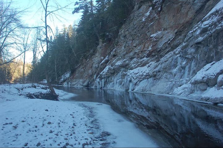
Hike to the Gypsum Cliffs and Hayes Caves
This is a 30min or 3 hr hike that starts right from the Yome. Don't follow the gps coordinates given though. Just follow the directions below. It is a beautiful walk on an old railroad bed that goes along the 5 mile river. After 30min you will arrive at towering gypsum cliffs and a perfect picnic spot. The cliffs are home to vast bat caves but they are off limits to human access because of the vulnerability of the bat population.
Here are the directions.
Go along our road past our land and follow the smaller road continues to the right and past the farm house. It goes down a steep hill and through an open field. Its a nice walk but most cars can also drive down here when there is no snow (go slow if you have low clearance). As the road enters the woods (7min walk from the yurt), it goes past a pine stand on the left, under an old apple tree and comes to a cross. Going left or right takes you along the old railroad bed. Right is a short walk before you reach a broken bridge. Going left for 2 minutes will take you to the 5 mile river where you can swim. Go 10 minutes and you'll reach a washed out bridge and you can see tall gypsum cliffs up to the right and in the distance. Take the path to the left and go through the stream or over the fallen ash tree. Follow the stream back to the river and follow the river along until you reach the cliffs. There are many paths here and it can be confusing. If you can catch a glimpse of the cliffs from the original path it can help you orient yourself. But all paths are pleasant and safe. From the cliffs you can go through the river (in the dry seasons) and to the right to find a trail that goes up, on top of them and down the other side (only for hikers. Be careful). You can also find the continuation of the rail road path and walk for an hour or two along it and (if you want to cross a feeder stream) you can get all the way to the Shubinacadie River. You can also follow any of the other trails you see but please be respectful of the land. It belongs to our generous neighbours. Also be careful of hunters in hunting season, animals and getting lost. None are real dangers if you are smart about it. Ask us if you have questions:)
Andy Hayes Road
Andy Hayes RoadThis is a 30min or 3 hr hike that starts right from the Yome. Don't follow the gps coordinates given though. Just follow the directions below. It is a beautiful walk on an old railroad bed that goes along the 5 mile river. After 30min you will arrive at towering gypsum cliffs and a perfect picnic spot. The cliffs are home to vast bat caves but they are off limits to human access because of the vulnerability of the bat population.
Here are the directions.
Go along our road past our land and follow the smaller road continues to the right and past the farm house. It goes down a steep hill and through an open field. Its a nice walk but most cars can also drive down here when there is no snow (go slow if you have low clearance). As the road enters the woods (7min walk from the yurt), it goes past a pine stand on the left, under an old apple tree and comes to a cross. Going left or right takes you along the old railroad bed. Right is a short walk before you reach a broken bridge. Going left for 2 minutes will take you to the 5 mile river where you can swim. Go 10 minutes and you'll reach a washed out bridge and you can see tall gypsum cliffs up to the right and in the distance. Take the path to the left and go through the stream or over the fallen ash tree. Follow the stream back to the river and follow the river along until you reach the cliffs. There are many paths here and it can be confusing. If you can catch a glimpse of the cliffs from the original path it can help you orient yourself. But all paths are pleasant and safe. From the cliffs you can go through the river (in the dry seasons) and to the right to find a trail that goes up, on top of them and down the other side (only for hikers. Be careful). You can also find the continuation of the rail road path and walk for an hour or two along it and (if you want to cross a feeder stream) you can get all the way to the Shubinacadie River. You can also follow any of the other trails you see but please be respectful of the land. It belongs to our generous neighbours. Also be careful of hunters in hunting season, animals and getting lost. None are real dangers if you are smart about it. Ask us if you have questions:)
Watching the Tidal Bore
The Bay of Fundy and the tidal bore that rushes down the Shubinacadie river is one of the Main tourist attractions in the area. If you park at the Interpretive Centre you can walk 2 minutes to a look off where you can see the incredible river and (if you time it right) the tidal bore.
8 personas locales recomiendan
Fundy Tidal Interpretive Centre
9865 Hwy 236The Bay of Fundy and the tidal bore that rushes down the Shubinacadie river is one of the Main tourist attractions in the area. If you park at the Interpretive Centre you can walk 2 minutes to a look off where you can see the incredible river and (if you time it right) the tidal bore.